ActiveOutdoorsWhat new symbols would you add to Ordnance Survey maps?British mapping agency seeks to improve the information provided on their maps to include bike repair shops, cafes, canoe launching points and moreWhen you purchase through links on our site, we may earn an affiliate commission.Here’s how it works.
ActiveOutdoorsWhat new symbols would you add to Ordnance Survey maps?British mapping agency seeks to improve the information provided on their maps to include bike repair shops, cafes, canoe launching points and moreWhen you purchase through links on our site, we may earn an affiliate commission.Here’s how it works.
British mapping agency seeks to improve the information provided on their maps to include bike repair shops, cafes, canoe launching points and more
When you purchase through links on our site, we may earn an affiliate commission.Here’s how it works.
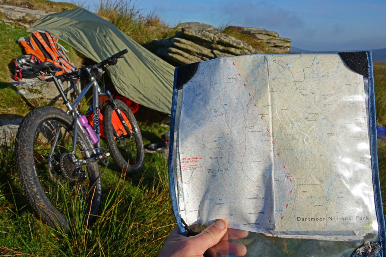
(Image credit: Pat Kinsella)
(Image credit: Pat Kinsella)
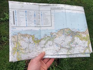
With a history that dates back to the Jacobite Risings and Napoleonic fisticuffs of the 18th century, when detailed maps of Britain were created for defensive and military purposes, Ordinance Survey maps were first published and made available to the public in 1801, and the quality of the cartography is widely considered to be the world’s best.
(Image credit: Ordnance Survey)
(Image credit: Ordnance Survey)
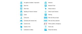
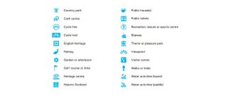
Besides natural features and manmade elements of the outdoor environment – such as footpaths, bridleways and trig points – topographical Ordnance Survey maps, currently indicate the location of things like churches and pubs. But, in a bid to make their mapping even more modern, informative and user friendly, the OS are about to expand the number of symbols used. On the list of potential new icons are cafés and canoe and kayak launching points – but what would you like to see added?
Think hard, because you will get the chance to put your suggestions forward. Ordnance Survey are planning to consult the public in coming months to see what new symbols are likely to be the most popular and useful.
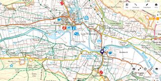
Ordnance Survey Leisure maps already include a huge amount of details and many symbols aimed at improving users' outdoor experience(Image credit: Ordnance Survey)
Ordnance Survey Leisure maps already include a huge amount of details and many symbols aimed at improving users' outdoor experience
Ordnance Survey Leisure maps already include a huge amount of details and many symbols aimed at improving users' outdoor experience
(Image credit: Ordnance Survey)
(Image credit: Ordnance Survey)
(Image credit: Ordnance Survey)
Existing OS maps already include more details than many people realise. For example, they don’t just indicate the location of a church, the symbols used specify whether the building has a pointy steeple or a square top, which can be incredibly useful when you’re navigating and want to be 100% sure where you are, and which direction you’re facing.
“The core purpose of our maps is to enhance people’s enjoyment of the outdoors,” Nick Giles, Ordnance Survey’s Managing Director of Leisure, told us yesterday, when asked about the new symbols. “A lot of the details the maps already include are navigational aids, which help people establish exactly where they are, but with digital mapping in particular, we can provide so much more useful information."
Kit list for walking
The days of wrestling with a large sheet map on windy hilltops are largely past, with the majority of walkers, climbers, cyclists and outdoor explorers now using digital devices to access their maps (even if the sensible ones still have a paper map in their pack as a backup in the event of battery failure). Although still popular with many people (enough to sell 2 million units a year) paper maps make up just 5% of Ordnance Survey’s business these days, whereas their app has over 5 million users.
Sign up to the T3 newsletter for smarter living straight to your inbox
Get all the latest news, reviews, deals and buying guides on gorgeous tech, home and active products from the T3 experts
While there are no current plans to include things such as E-vehicle recharging points, because of the pace of change in this area, it’s not something OS are ruling out for the future, especially for their digital cartography.
(Image credit: Pat Kinsella)
(Image credit: Pat Kinsella)
The new symbols, when they are decided upon and rolled out, will be added to digital platforms first, before being included on paper maps as updates are made and reprints done. Nick acknowledges that, in a fast changing environment, it’s tricky to keep details current, but says the agency works with third parties such as the Good Pub Guide to try and ensure the places included on maps are open, and says user feedback is also invaluable in this respect.
Nick told us that the process of nominating new symbols will begin with a consultation with core customer groups, before being thrown open to everyone across social media channels and the wider media, most likely around September time.

The biggest Samsung Galaxy S25 leak yet reveals specs, Galaxy AI features and a lot moreThere are going to be some big changes with the new Samsung phones
There are going to be some big changes with the new Samsung phones

I tried the Insta360 Flow 2 Pro gimbal and it’s the ultimate tool for creators who want cinematic resultsNext-level AI tracking and pro features make this gimbal a must-have for serious iPhone filmmakers
Next-level AI tracking and pro features make this gimbal a must-have for serious iPhone filmmakers

Change my mind: the smaller, the better with portable power stationsPut your portable power station to work when you’re not using it
Put your portable power station to work when you’re not using it

This rugged adventure Garmin is mega cheap in Walmart’s Black Friday saleThe Instinct 2 is a top watch for outdoor and sport enthusiasts
The Instinct 2 is a top watch for outdoor and sport enthusiasts

YETI’s best-selling products are ridiculously cheap in Amazon’s Black Friday saleFancy yourself a tumbler, rambler or cooler? Amazon’s reduced them all
Fancy yourself a tumbler, rambler or cooler? Amazon’s reduced them all
AKASO Seemor 200 night vision goggles review: unparalleled clarity for nighttime adventuresAKASO’s new NVD unlocks the night with cutting-edge colour vision technology
AKASO’s new NVD unlocks the night with cutting-edge colour vision technology

8 must-have hiking gadgets for tackling cold and wet trailsWhether it be wet and rainy, or super chilly, these 8 gadgets can make your outdoor adventure even more enjoyable
Whether it be wet and rainy, or super chilly, these 8 gadgets can make your outdoor adventure even more enjoyable
Vango Classic Instant 300 review: a festival-goer’s dream tentSuper quick to pitch and pull down, this reasonably priced tent is spacious, tall and well-featured for festival use
Super quick to pitch and pull down, this reasonably priced tent is spacious, tall and well-featured for festival use
Is Columbia’s OutDry Extreme the best waterproof-breathable material that no one is using?ODX hasn’t revolutionised the outdoor apparel world in the way its creators expected it to – but that could be about to change…
ODX hasn’t revolutionised the outdoor apparel world in the way its creators expected it to – but that could be about to change…
Best YETI coolers 2025: ice cold excellenceKeep food and beverage frosty with our curated selection of top-rated YETI coolers for every occasion
Keep food and beverage frosty with our curated selection of top-rated YETI coolers for every occasion
